Madison County, IN
Cemetery Information by Township:
Many of these links will refer you to the pages of the Madison County Cemetery Commission website that has lots of fantastic information.
GREEN TOWNSHIP [Ingalls, Alfont]:
Click on the cemetery below to see a list of pioneer burials, history, bits of biographies, and pictures.
CREDIT to the Madison County Cemetery Commission for the following interactive map!
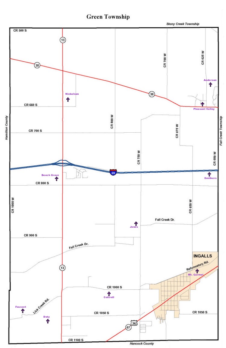
Pioneer Cemeteries:
Alfont or Bolander (Destroyed),
N side of CR 1050S, W of Alfont /GPS N40.03.050; W085.34.274
---------------------------------
between SR 132 & SR 38, E of CR 625W, south of Fosters Creek /GPS approx. N40.01.108; W085.47.076
---------------------------------
W side of SR 13, between I69 & CR 800S/ GPS N39.59.478; W085.50.646
---------------------------------
S side of Reformatory Rd., E of SR 13 /GPS N39.31.266; W085.51.276
---------------------------------
W of American Legion Park, W side of SR 13, N of Fortville /GPS N39.56.994; W085.51.059
---------------------------------
N side of Reformatory Rd.; between SR13 and bridge crossing Lick Creek/ GPS N40.00.443; W085.35.230N39.57.103; W085.51.825
---------------------------------
E side of SR 13 on Reformatory Rd., across from Gravelawn/ GPS N39.57.287; W085.50.596
---------------------------------
W of CR 750W, N of Fall Creek Drive/ (No GPS Avaiiable)
---------------------------------
E side of CR 750W, between CRs 800S and 900S / (No GPS Avaiiable)
---------------------------------
S side of Reformatory Rd., E of CR 650W/ GPS N39.57.903; W085.47.512
---------------------------------
E side of SR 13, between SR 38 & CR 650S/GPS N40.00.675; W085.50.576
---------------------------------
NW corner of SR 38 & CR 625W /GPS N40.00.595; W085.47.491
---------------------------------
W side of CR 600W, between SR 38 & I69 (No GPS Available)
---------------------------------
Other Cemeteries:
Fort Cemetery
Ingalls, Madison County, IN
Degrees Minutes Seconds:
Latitude: 39-56'59'' N
Longitude: 085-51'47'' W
---------------------------------
9088 W County Road 1025 S
Green Township, Madison County, Indiana, 46040